Geographical Context
Jabal was named after the struggle from the mountains of northeastern Balochistan, where the BPLF set up insurgent camps to fight the Pakistani military during the 1973 to 1977 counterinsurgency operations.

▴ 1 of 2 — The Thadri Mountain, where the BPLF set up their first camps. As the struggle spread across other parts of northeastern Balochistan and beyond, camps were set up in other mountains further afield. Source: Personal photo archive of Mir Muhammad Ali Talpur.


Image 2 – Hand-drawn illustration of BPLF fighters watching the Pakistani military from the mountains of northeastern Balochistan. Source: Jabal, Vol. 1, No. 8, August 1977.

Image 3 – Hand-drawn illustration of an armed BPLF fighter standing in front of sheep grazing on the mountains. Source: Jabal, Vol. 1, No. 2, January 1977.
In hand-drawn images across several issues of Jabal, BPLF fighters are illustrated watching tanks and soldiers enter “hitherto unconquered mountains.” 1Jabal, May 1977, Vol. 1, No. 5., often armed and through binoculars.
These images and accompanying text in Jabal present the mountains as a privileged site of revolutionary politics: as vertically distant, and difficult to navigate by military forces, the mountains served as a place of political refuge for those trying to avoid military violence. Fighters who grew up on the mountains could use their local knowledge of its terrain to avoid repeated attempts by the Pakistan Army to cordon off all exit and entry points. They could also surreptitiously find grazing grounds and water holes for their families to circumvent attempts by the military to block incoming rations needed for survival.

Image 4 – Access to water holes, like this one, were crucial to the survival of mountain communities, especially when they were fighting the Pakistani military. Source: Personal photo archive of Mir Muhammad Ali Talpur.
In the years leading up to the first issue of Jabal in 1976, a three-year drought had put immense pressure on targeted mountain communities. They were able to survive water shortages because of a deep intimacy with the mountains. Understood as a harsh enemy, they used their deep knowledge of the terrain to tactically avoid the military might of the state. This distance of the mountains from state power, and their continued inaccessibility and illegibility to the state, were in the eyes of Jabal’s authors the conditions of possibility for a more autonomous and egalitarian vision of collective life.
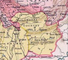
Close-up of “Marri Country” and “Bugti Country” on a colonial-era map of Balochistan. The Marris and Bugtis were considered particularly “fanatical” in British racial narratives of Balochistan’s tribal formations, and were separated out for separate governance. Source: Public Domain Image via Wikimedia Commons.

Full view of colonial-era map of Balochistan. Source: Public Domain Image via Wikimedia Commons.
Northeastern Balochistan, where these mountains are nestled, remain sites pregnant with the memory of rebellion by indigenous Baloch, including the Marris, Bugtis, and Khetrans, against outside forces. These outsiders included the “Arabs, Huns, Persians, Afghans, British colonialists, or imperialist stooges” according to Jabal. 2Jabal, March-April 1977, Vol. 1, No. 4. After the 1839 colonial annexation of Kalat, when the British Raj constituted the main, foreign aggressors, armed rebellion by Marris, Khetrans, Bugtis, and other tribal formations in northeastern Balochistan were so common, that the Raj decided to govern them separately. The colonial mapping of Balochistan, which ended up determining the contours of what later became the Pakistani province of Balochistan, shows that the British had separated out “Marri Country” and “Bugti Country” because of frequent armed rebellions.

A letter declaring the “Boogtis” as “outlaws” who can be “captured or killed when they come near the frontier” and whose cattle can be seized. Source: Mir Muhammad Ali Talpur personal archive of colonial documents.

The front cover of the Pakistani English-language newspaper Dawn, on how the Khan of Kalat, the head of a major princely state in central Balochistan, resisted the Pakistani military’s attempt to subsume Kalat State into Pakistan. He was subsequently arrested and accused of sedition. Source: Image of Dawn in the personal archive of Mir Mohammad Ali Talpur.
Really, this separation indexed racial tropes by the British that cast all resistance to British colonial rule as “fanatics” and “outlaws”; such stereotypes in turn justified the separate governance of the “wild tribes” of the hills and mountains under draconian laws like the Murderous Outrages Act (1867) and Frontier Crimes Regulation (1872) which gave legal cover to colonial political officers to kill anyone they deemed “fanatical”, without trial. After the 1947 Partition and Independence of Pakistan, which in the eyes of several Baloch nationalists included a 1948 annexation of Balochistan despite a stated desire to maintain substantial autonomy from the new postcolonial state, these northeastern communities retained a reputation for being particularly averse, if not outright hostile, to outside rule.
While their recalcitrance was read as backwardness by the outsiders who tried to rule them, they are remembered in the epic war ballads of the region’s local poets, like Rahm Ali Marri (1875-1933) under the British Raj, as signs of heroic, anti-colonial resistance.
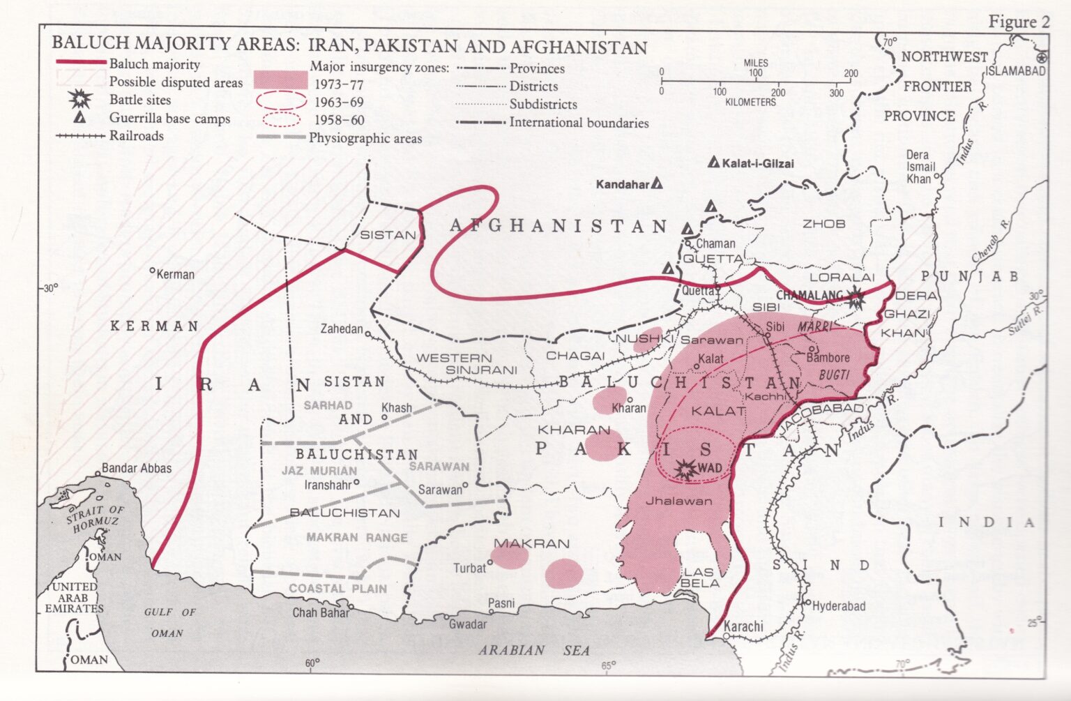
▴ Areas highlighted in red in this image show which territories constituted the major insurgency zones during the 1973 to 1977 insurgency. As is clear, the insurgency spread through Kalat, Jhalawan, Sarawan and Sibi–and existed in places as far afield as Makran, Kharan, and Nushki. Source: Harrison, Selig. 1981. In Afghanistan’s Shadow: Baluch Nationalism and Soviet Temptations. Carnegie Endowment for International Peace.
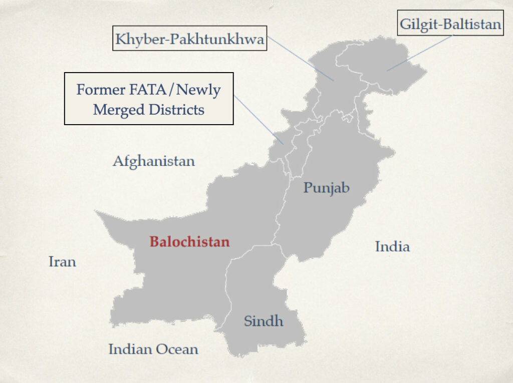
Contemporary map of Pakistan. Source: Designed by Mahvish Ahmad.
Though the BPLF started out fighting the Pakistani military in the northeastern regions, the struggle quickly spread to other parts of the province which had their own memories and experiences of protracted rebellion against outside sovereigns. Firefights and ambushes occurred with regular frequency not only in northeastern areas dominated by the Marris, but also in other parts of Balochistan like Bolan, Jhalawan, Sarawan, and Makran, albeit under a different set of leaders. This included Ali Mohammad Mengal in Khuzdar, Safar Khan Zehri in Jhalawan, and Aslam Gichki in Makran, among other people. According to one set of government statistics, while 84 out of 178 army encounters took place in the northeastern Marri areas in 1974, the rest were scattered across Balochistan, with places like Khuzdar and Jhalawan in central and southern Balochistan especially targeted. 3Harrison, Selig. 1981. In Afghanistan’s Shadow: Baluch Nationalism and Soviet Temptations. Carnegie Endowment for International Peace.

A hand-drawn map of an imagined “Greater Balochistan” carried by the weekly Al-Baloch, Karachi, in its issue of 25th December, 1932, on page 7. Source: Baloch, Inayatullah. 1989. The Problem of Greater Balochistan: A Study of Baloch Nationalism. Hamburg: Beiträge zur Süudasienforschung [Hamburg].

A map of the Indian Ocean south of Balochistan’s coast. Source: Murer, George. The Forging of Musical Festivity in Baloch Muscat: From Arabian Sea Empire to Gulf Transurbanism to the Pan-Tropical Imaginary. Ethnomusicology Review, UCLA.
The connected armed insurgency against Pakistani military operations was possible because those who took part considered themselves members of a shared Baloch national identity that connected them, at times across vast distances (the province of Balochistan is nearly as large as Germany and constitutes 44 percent of Pakistani landmass). This political and affective connection was premised on a territorial imagination that transgressed and exceeded that of the Pakistani state. Twentieth century Baloch nationalists, for instance, imagined a “Greater Balochistan” that stretched from southern Iran and Afghanistan through to the colonial province of Balochistan. This imagination still animates Baloch nationalist separatists today. This broad, territorial imagination also mobilised Baloch students living in the city of Karachi, in the neighbouring province of Sindh, to join the battle against the Pakistani military’s operations (see Political Movements). Of course, not all Baloch shared this nationalist identity.
For instance, southern fisher communities along the coast facing the Indian Ocean saw themselves as more integrated into trans-oceanic networks that stretched from eastern Africa and western India, and at times saw themselves as direct subjects of the Sultanate of Oman which ruled over a section of the southern Makran coast before handing it over to Pakistan in 1958. 4Jamali, Hafeez. 2014. A Harbor in the Tempest: Megaprojects, Identity, and the politics of Place in Gwadar. PhD Dissertation, University of Texas at Austin, p. 22-23.

▴ One of the more famous maps of what Pakistan could look like, which illustrates this top-down and homogenising view of Indian Muslims, was produced by Choudhry Rehmat Ali while he was a law student at Cambridge. Source: Choudhry Rahmat Ali’s pamphlets from the collections of the Centre of South Asian Studies, University of Cambridge. Source: Tryst With Destiny, University of Cambridge [Retrieved: 5 October 2021].
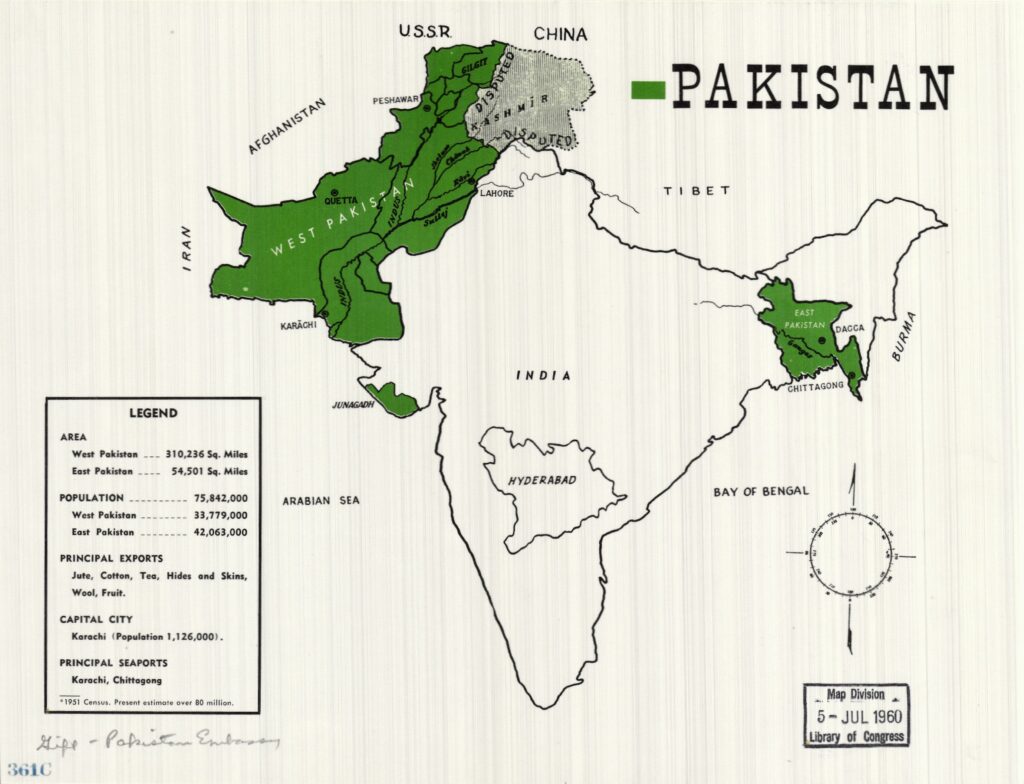
A map of Pakistan in 1960, which shows the amalgamation of all of West Pakistan into One Unit, to counter the power of East Pakistan. Source: Geography and Map Division, Library of Congress.
These transgressive territorial imaginations ran counter to the Pakistani state’s understanding of Balochistan. Early imaginations of Pakistan lumped together all Indian Muslims in separate, territorial entities, despite the vast differences in languages, cultures, ethnicities and more that actually existed between them. This lumping generated trenchant resistance from Pakistan’s minoritised ethnicities, nations, and languages, including Baloch nationalists who were critical of top-down attempts to marginalise indigenous languages and cultures through the imposition of Urdu and to centralise power in a federal government and military dominated by the country’s Punjabi and Urdu-speakers. To counter the most forceful criticism of this centralisation – which came from Bengalis in what was East Pakistan until the secession and independence of Bangladesh in 1971 – Prime Minister Mohammad Ali Bogra fused the entire, territory of what today constitutes Pakistan (and back then, constituted West Pakistan) into One Unit. It was not until 1970, after a protracted resistance against the One Unit Policy, that Balochistan even emerged as a separate province. This constant attempt to refuse power-sharing prompted Jabal authors and the broader Baloch struggle to see Pakistani state power as an instance of internal colonial rule, a lens that continues to animate Baloch nationalist critiques of state rule in Balochistan today.

A map of natural resources subject to the economic interests of global and national companies in Balochistan. Source: Harrison, Selig. 1981. In Afghanistan’s Shadow: Baluch Nationalism and Soviet Temptations. Carnegie Endowment for International Peace.
More importantly, the Pakistani state imagined the territory of Balochistan as a site of potential resource extraction that could power the rest of the country, and began carrying out geological explorations of resources like oil, gas, and minerals potentially available within the province. The most important discovery within Balochistan was made in 1952, with the discovery of Sui Gas in northeastern Balochistan’s Dera Bugti; from 1955 until today, Sui Gas constitutes the majority of gas provided to the rest of country. However, gas was never supplied to Balochistan itself, and has, most notoriously, yet to be supplied to the surrounding Sui Town from which it is extracted. On the pages of Jabal, this exploitative relationship between the central state and Balochistan lands was exacerbated after the 1971 secession of East Pakistan and independence of Bangladesh, which meant an important site of exploitation was now unavailable. In one essay, entitled Imperialism, Oil and the Baluchistan Revolution, they argue that post-Bangladesh “a deal with Imperialism, especially the United States and Iran, became imminent” resulting in Pakistan offering up Balochistan: “Balochistan was sold. Minerals, oil and her people were auctioned, bit by bit, to the highest bidder.”
Central to Jabal’s political message is an idea that such state-centric ideas of how people should relate to one another, for instance as colonial subjects loyal to the violent British Raj or subjects central to a repressive and exploitative postcolonial states, should be challenged. Against these state-mediated relations, Jabal calls for the forging of transgressive relations between repressed communities and political struggles inside and outside Pakistan to bring about a communist, anti-colonial and anti-capitalist world order. Read more about these counter-alliances in Networks.
- Jabal, May 1977, Vol. 1, No. 5.→
- Jabal, March-April 1977, Vol. 1, No. 4.→
- Harrison, Selig. 1981. In Afghanistan’s Shadow: Baluch Nationalism and Soviet Temptations. Carnegie Endowment for International Peace.→
- Jamali, Hafeez. 2014. A Harbor in the Tempest: Megaprojects, Identity, and the politics of Place in Gwadar. PhD Dissertation, University of Texas at Austin, p. 22-23.→